After a quick discussion with @Kirsten on it I thought I would open a thread to start gathering inputs and align our vision on it.
I always say when pitching the OFN that we are both a tool and a community. A tool to enable food hubs to operate. And a community encouraging each food hub to document and share operational & business models, learn from each other, build on each other, understand the different models of food hubs, etc.
On this community side, I usually take the image that on the OFN map, our vision is that soon we can find on the map, if you zoom on a territory, all the local and sustainable food ecosystems. Some are using the tool OFN, some are not, and it’s fine, each initiative is free to choose the tool that fits them best.
This argument works particularly well when talking to “local public bodies” (state, county equivalent representatives) and we hope we can manage to rally them to the OFN and start using the OFN to map their local food ecosystem
This could be part of an instance business model, that’s what we are trying to push in France.
Let’s imagine together, how we could map the whole ecosystem on this map:
For that to be real this would require to evolve a bit the mapping tool. For me that includes:
first enable to use the Open Street Map database so that we take the opportunity of mapping local territories to enrich another friend Commons If that is difficult for some instances to switch from Google to OSM, then we should find a way to let every instance decide if they want to build up on the OSN or on Google.
then think of a series of icons that would symbolize the different types of food hubs. This also should be customizable by each local instance. For example in France we would want to map FoodAssemblies, Locavor hubs, CSA (AMAP in French), informal buying groups, cooperatives stores, local food webshops, farmers markets, organic farmer member Via Campesina (or local engaged producers labels or groups), etc. With something that identifies clearly the hubs using the OFN tool (like a small star, or a small carrot, superposed with the icon…).
then as it’s going to be super messy we need to be able to filter on the map to see only this or that type of food hubs (ex: I want only to see the Food Assemblies I can hide all the other dots on the map)
I hope we can make that move in the first months of 2017 as we are going to meet with regional representatives.
I like the way you open a conversation about OFN - similar for me here. Except here, I stress the social justice potential also. I also stress the importance of a globally linked network.
Re the map - in January I have a research assistant working with me who is going to begin calling hubs, CSAs, and other sustainable food initiatives to offer to create profiles for them. I think the map potential of OFN is equal to or greater than the logistics tools for the reasons you outline @MyriamBoure. In Canada, most farms, markets, hubs, artisans, CSAs pay to be listed on such a map now - everywhere we have groups making ‘Buy Local Buy Fresh’ maps - which have the kind of filtering and searching you describe. These maps are quite localized - usually a few municipalities and rural townships working together (maybe 500,000 population) . They are developed primarily by not for profit groups, sometimes with municipal government (tourism) funding. They then turn these into printed maps also (quite lovely in some cases). These maps are distributed free - which is why they charge - and there is a very high level of awareness about them now. Here is the on-line map for the region live in (you can see my farm - ‘Garden Party’ http://www.foodlink.ca/index.php?p=food_maps/map.SearchResults&search=delivery%2C+csa#outlet19
A few interesting features we might think about if we go down this path: lots filters needed as Myriam notes, a nice feature is to be able to search for only open locations, on this map there is a + sign used to zoom into a more precise location…
The biggest drawback of these maps here in Canada (and why I see new possibilities for OFN) is that they are not connected - primarily because each is governed by set geopolitical boundaries. So when you zoom out on the example above - it seems like there is nothing there. Of course, we are global - so that opens up lots of possibilities.
Would there ever be a way to ‘import’ entries from such maps that exist into OFN? I think here, most of these groups would be interested in that kind of partnership with us.
I am really entusiastic about this idea!
Actually I will do this separately for now on my Site s-kmetij.si (“from farms”) for Slovenia (agen local as @tschumilas noted). Just for idea I describe here how I am composeing it:
It is WordPress with GeoDirectory plugin (it is one of many, but seems to have what I need). Basic is good operability of data: import/export categorising/tagging, searchability of data and represention on map (open street map).
For full operating system in this case one need payable addons. (GD = $150/y for all for unlimited installs).
OK, it may seem as advertisement, but I want to share what I learned and I think it is best way to start discussion with something as concrete as possible.
You can display on map any category (OFN, FoodAssembly, Organic, Manupacity…) separately.
Is there any functionality missing (except integration to OFN platform ;-)?
Eventually we could make local installs for countries and one global. And make interoperability in such way that as you zoom into country it loads local instalation.
Problem are border regions but that could be managed on local installs with dsta exchange protocols we anyway want to integrate.
And by this Open Food Directories we make traceability of individually traded foods (and goods) posible. Each enterprise get somekind of ID or number of which last three are to be defined by enterprise for product. (eg. US1234PROD123). So end shop can just specify that ID and buyers can see exactly where products come from (aditional numers for all of traders and shippers in between are also available and posiple aggregate in shipment trace).
What you think?
The intent of this is great, I’d like to pose some questions:
The Data Food Consortium notwithstanding, could OFN aiming to be the directory for all have any conflict with those who offer similar services?
So might that suggest a separate system or site? Perhaps it could be a separate sub-domain under OFN, e.g. directory.openfoodnetwork.xyz but that would still be a separate website.
Also there could be a distinction between the organisational/commercial/political side of this and the technical. From a techincal PoV, it might be worth considering a separate app that can evolve independently of the core OFN app. An advanced directory might look something like http://sharecity.ie/research/sharecity100-database/, which does quite a lot of filtering. Also pulling all the data together is a challenge (just ask Transformap) so simpler tools that just focus on this task might be easier to work on than adding more to OFN which is already a complex system.
I’m also quite inspired by the GDS work on registers (e.g. see the country register) that do one thing and do it well.
Might also be worth connecting with GODAN - there are some people at the Open Data Institute who are working on this (perhaps this point is more related to Open Data Consortium).
@pmackay great suggestions!
Sharecity seems to have what I imagine data represenion should be like.
I think we should contact to all of initiatives like this are as long as their governance fit to our VALUES.
I like the idea!
Thinking of other directories, many list relevant businesses without even asking the business first and then they offer a link to “claim” the business, if it’s yours. Not saying that’s how we should do it but it would make the directory grow quickly and hence make it more relevant sooner.
Thank you all for your feedbacks [quote=“pmackay, post:5, topic:771”]
The Data Food Consortium notwithstanding, could OFN aiming to be the directory for all have any conflict with those who offer similar services?
[/quote]
I’m not sure… for me Open Food Network is more positioned as a public infrastructure than a competitor to other similar services… so if our positioning is a public infrastructure one, we say anyone can use us, whether if be a Food Assembly, a CSA, or any other initiative aligned with our values. But as a public infrastructure, we can also allow (and encourage) initiatives using other infrastructures to appear on this public directory.
For me if The Food Assembly or other food platforms want to do the same and display also other food hubs initiatives, they can do it, this is really for me the vision of web interoperability, it’s not building third neutral places, but interconnecting within each application data from other applications.
We will see while the discussions move forward if there are oppositions from other applications to appear on the OFN public directory, and if there are objections we’ll find other solutions, as you suggest probably, but my dream would be more the one of a distributed web than multiple external directories that you then need also to market, reference, etc.
If we think it’s easier to integrate an external mapping tool than evolve our, that is definitely an option, then all the OFN existing profiles should migrate to that new visualization and research tool. The Sharecity platform doesn’t seem open source though. But we could build an open source version of it adapted to our need. Or I’m pretty sure Open Street Map have some mapping tools with custom filters so we could have a “food hub map” based on an OSM public server, and embedded in OFN (and that other food platforms could embed in theirs and choose while embedding if they want to display all data or just some of them, like only their own hubs). With a default filter that display all hubs, but the possibility to only display the OFN hubs, or the food assembly hubs, or this or that.
Ideally the data for the directory of hubs should be connected via an API to the original directory (for example the Food
Assembly manage their directory somewhere, they could connect through the API to make all their hubs appear instantly on the map?) There is a question of update of the information, API seems to me the more relevant way to work on that as it insures the data are updates when they are update from the original source. If that’s another database to fill in each time a new hub is created, we can be sure new hubs won’t be added and old one won’t be removed as people will just forget.
I like your suggestion @Oliver, to take the leadership to map all the hubs on a territory and them ask them to claim it
I think we should join http://transformap.co efforts.
To present all of the food ecosystem on map is way to change it, as it makes people think. We want it decentralised and interoperable. @MyriamBoure you work wit OuiShare, how far is this project?
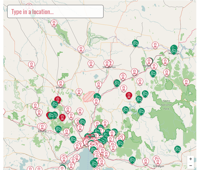
@Kirsten@sstead@MyriamBoure - pinging you folks because you’ve been involved in the directory and mapping issues for longer than me. I’m trying to set up some directories and maps here - and I am having trouble figuring out the icons we currently have. I think a tractor means a producer - selling own or none (profile only). But when are icons filled vs empty? Is there a key somewhere?
I’d love to help move forward re-thinking the directory issues.
Tractor means producer, red means hub. So red tractor means producer that manages a shop. Green tractor profile only (can source hubs but doesn’t manage a hub).
So hubs that are not producers are the red “localize” icons. Entities who uses the OFN to organize trades.
White “localized” icons means “profile only hub” so a hub who doesn’t use the OFN to trade.
Is that clearer?
All that definitely needs to be rethought but we have not prioritized it yet, but of course nothing prevents your to think and share ideas on that already @tschumilas
I think this would be an amazing project. I think we might evolve additional filters that emphasize food sovereignty. Otherwise - this could become a map of supermarkets, restaurants, and mega farms everywhere. So for me, the filtering is what makes this unique. We want our map to curate specific kinds of food system actors. So - the discussions about ‘which kinds?’ need to happen along side the technical development. I’d really like to be part - and I’m going to discuss this with my colleagues at the Centre for Sust Food Systems to see if there is interest, and potential funders. I also think one of our current funders (who is paying for spree upgrade work) might be interested in this as a next project. Might a next concrete step be to set up a discussion zoom?
Thank you @tschumilas! Actually we will have a call soon with WWF national team about joining forces on that as they do have a similar project. I want also to connect with Virtual Assembly who have done some nice mapping for citizen alternative projects. If you have news on your side let me know. I’m not prioritizing this project though as we have a lot to do but moving slowwwwly when doors open